Sunday, September 20, 2009

September 12, 2009: Oktoberfest in Red Lodge, MT!

Oktoberfest comes early to Red Lodge, Montana... by October, the weather is already too cool for an outdoor festival in the park whereas September weather is beautiful... at least it was this year! I've included a few photos of the festival which are probably only of interest to those pictured... but we didn't really do much else on the day of the festival. A good time (too good a time?) was had by all as we drank an Oktoberfest brew (by beermeister Sam of Red Lodge Ales) or two or more, ate bratwurst, knackwurst, German potato salad and danced to the music (early in the day... oompah... later in the day... blues and rock and roll provided by the Firehouse Band of Billings, MT).

Victoria in German dress
The dirndl I'm wearing was purchased on EBay for about half what 'authentic' German online clothing merchants wanted... it was fun to dress for the occasion.
Hillary and Vanessa
Beer maidens Hillary and Vanessa on break from serving beer.
Betsy and Mom Millicent
Mayor Betsy with Mom, Millicent, modeling the hat awarded to the Oktoberfest Queen elected each year.
Wyatt on a mission
One of the youngest Oktoberfest participants dressed in authentic costume... Wyatt was later voted Oktoberfest king for 2009...
Maryvette throwing the keg in keg bowling
Keg bowling was just one of the games for Oktoberfest... here Maryvette throws for what she hopes will be a strike (it wasn't) as the crowd watches.
Lindsey in German dirndl
Lindsey in her authentic German dirndl... one of the organizers who helped make Oktoberfest a smashing success again this year.
Sam of Red Lodge Ales
Sam, beermeister and owner of Red Lodge Ales...
Victoria and Mike dancing
This photo of us dancing to the Firehouse Band at Oktoberfest was provided by one of the people we met that day...

Saturday, September 19, 2009

September 10-11, 2009: Red Lodge, MT with friends

This post may only be of interest to family and friends... or those who would like to know more about what is available in the way of food, friends and fun in the Red Lodge area. At this point in our vacation, I'm having trouble remembering exactly what we did each day but have a few memorable moments to share in pictures! (when you get to the photos mentioning Wolfie's spot on Red Lodge Mountain... Wolfie was our friend Tim's dog who is no longer with us... we leave you to conclude what is meant by "Wolfie's spot" on Red Lodge Mountain)

No trip to Red Lodge is complete without a trip to Roscoe, MT for a marvelous steak dinner at the Grizzly Bar. Below are snapshots of friends Mary and Evan and of Mike and myself in the parking lot prior to our annual fine dining experience at the Grizzly.
evan and mary at grizzly bar victoria and mike at grizzly bar

On the next day, we started out in the morning with a 'townie' bike ride (or girlfriend ride as Mike likes to call it when he goes slow) and here's a photo of Mary, Evan and Mike on one of the bridges across Rock Creek.
mary, evan and mike

After our townie ride, Mike and Evan went mountain biking while Mary and I were treated to a ride up Red Lodge Mountain, courtesy of our friend Tim, where we had a picnic lunch at Wolfie's spot with spectacular views of the ski runs (below) and the valley and palisades (subsequent photos)
Red Lodge Mountain ski runs

palisades and valley as seen from Red Lodge Mountain
Tim setting up for our picnic lunch... spectacular view in the background...
palisades and valley from Red Lodge Mountain
View of the palisades and valley from Wolfie's spot on Red Lodge Mountain..
dog in back of truck
Koda, Tim's current dog, is one happy camper riding in the back of Tim's truck.

The last two photos show the end of our adventure up the mountain with Tim (we stopped to look back at the entrance to Red Lodge Mountain) and the last evening of our visit with friends Mary and Evan (the best of our squinty eyed photos taken at Sam's Tap Room looking into the sun) before their return to real life back home in Maryland.
entrance sign for Red Lodge Mountain four friends at Sam's Tap Room in Red Lodge, Montana

Friday, September 18, 2009

September 9, 2009: Beartooth Highway Adventure...

Mike unfortunately had to work today... so Mary, Evan and myself drove up the Beartooth Highway until we hit the construction at the Montana/Wyoming border at which point we turned around and came back down the mountain. For those of you unfamiliar with the Beartooth Highway... it is the stretch of route 212 from Red Lodge to Cooke City, MT and was described by Charles Kuralt as "the most scenic drive in America."

What follows are a few photos of the adventure experiencing the scenic beauty of this wonderful road... a route I never tire of no matter how many times I drive it. From several vantage points along the Beartooth Highway, the Hellroaring Road and Plateau are beautifully visible!

rocky outcropping on Hellroaring road
You may recall from yesterday's post that we drove up the Hellroaring Road to the Plateau... the rocky outcropping in the above photo is the spot where we stopped and had our lunch yesterday.
end of road on Hellroaring Plateau
Look closely and you will see the last couple of switchbacks before reaching the top of Hellroaring Road... we parked our car at the end of this road yesterday and explored the plateau on foot for an hour or more.
jeep trail on Hellroaring Plateau
The road seen here is a jeep trail on top f the Hellroaring Plateau that is no longer open to vehicular traffic.
Hellroaring Road and Plateau as seen from Rock Creek Vista on the Beartooth Highway
Hellroaring Road and Plateau as seen from Rock Creek Vista on the Beartooth Highway...
ALTtag
Another view of the Hellroaring Plateau as seen from the Beartooth Highway... the switchbacks in the center foreground are lower down on the Beartooth Highway.

Thursday, September 17, 2009

September 8, 2009: Hellroaring Plateau Adventure

Post updated July 25, 2012: Our 2008 attempt at navigating the 7 miles of ROUGH road to reach the top of the Hellroaring Plateau failed due to snow drifts (before) and downed logs (after) blocking the road near the spot where we ate our lunch in June of 2008. Snow is almost always melted by August so we vowed that 2009 would be the year we made it all the way up the road to the very end where we would then wander around and explore the plateau. Although this road is definitely NOT for the faint of heart, nor would we recommend it for anyone with back problems since it is 7 miles of bouncing around no matter how carefully and slowly one drives, the views to be had are spectacular.

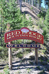
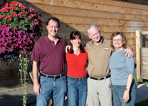
Friends Evan and Mary, Mike (driving our "Hyundai Santa Fe") and myself set out from our vacation home in Red Lodge, MT at about 10:00 AM on a gorgeous, sunny day ... destination Hellroaring Plateau. After a stop at Café Regis for sandwiches and chips for lunch, we were on the road and shortly bouncing along at a very slow pace up Hellroaring Road. Enjoy the day with us through photos included below...

Hellroaring Road as seen from Rock Creek Vista point on the Beartooth Highway (route 212) out of Red Lodge, MT
Hellroaring Road as seen from Rock Creek Vista point on the Beartooth Highway (route 212) out of Red Lodge, MT... this is the road we followed to the summit in our September 8, 2009 adventure (this photo was taken on September 7, 2009)
Beartooth Highway as seen from Hellroaring Road
View of the Beartooth Highway from part way up Hellroaring Road... we were at approximately the same elevation here as the photo taken the previous day looking toward Hellroaring Road from Rock Creek Vista lookout on the Beartooth...
Views of the Beartooth Highway, Rock Creek and Hellroaring Roads
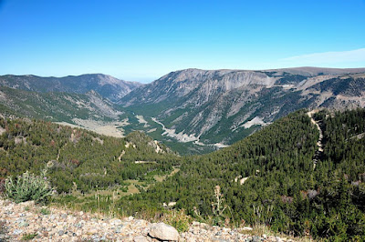
Views of the Beartooth Highway (right, with ends of some switchbacks visible at extreme right), Rock Creek (middle, up the valley) and Hellroaring (left) Roads as seen from where we ate lunch on our way up to the Hellroaring Plateau...
Victoria, Mike, Mary and Evan
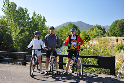
Intrepid adventurers Victoria, Mike, Mary and Evan on rocks at our lunch spot overlooking the Rock Creek Valley on Hellroaring Road...
coming down a rocky spot
Sometimes, the safest way down from a high rock outcropping is on your butt... Evan (below) and Mike (above) watch Mary make her way down from a place I would not go!

Rock Creek Valley
Looking up Rock Creek Valley toward Glacier Lake (not visible) from the same spot where the photo of Mary scrambling down the rocks was taken...
Mount Rearguard as seen from Hellroaring Plateau
Mount Rearguard - 12280 feet high... it's possible to hike to the summit but we didn't as we weren't properly prepared for such a hike... this year!
ALTtag
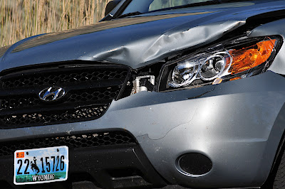
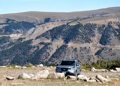
Our deer-dented, faithful vehicle in the parking area at the end of the Hellroaring Road... there are jeep trails beyond the parking area but vehicles are no longer allowed to go past the spot where we were parked in order to preserve the natural beauty of the plateau...
view of switchbacks on Hellroaring Road
Look at all those switchbacks, barely visible through the trees below... view of the Hellroaring Road from near the top of the road to the plateau...
Hellroaring Road descending with Beartooth Highway across the valley
Another view looking down Hellroaring Road and across the valley to the Beartooth Highway...

Wednesday, September 16, 2009

September 7, leaving the park and heading to Red Lodge, MT...

Am way behind with write-ups on this trip... have had a hard time making time to edit photos and then post! We left Yellowstone Park under sunny skies after a nice breakfast in the dining room in Mammoth. Destination... Red Lodge, MT and our vacation home there via the Beartooth Highway after leaving the park through the Northeast Entrance. With no further blathering... I'll just show you highlights of our day in pictures...


young male elk
We didn't make it very far before we were treated to the sight of a large bull elk and his herd resting in the shade of the buildings in Mammoth village. This is one of the young elk (who seems to be chatting away) in the herd and the only other male we saw. (clearly no threat to the big bull elk who had at least a 12 point rack!)
Mammoth Hot Springs, distant view
Just before crossing the Gardner River, we stopped for a last look back at Mammoth Hot Springs... even from a distance it is quite the sight!
male buffalo
Lone bull crossing the road... stops traffic and gives me an opportunity to snap a bison in sunlight as he enters the field by the roadside!
Pilot and Index Peaks, Wyoming roadside view
Pilot and Index Peaks as seen from the 'sitting rock' we found for our lunch break at the Pilot Peak lookout spot along the road to the summit of the Beartooth Highway...
Hell Roaring Plateau and the road to reach it
The road in this photo (up the valley) takes one eventually to the plateau known as Hell Roaring Plateau... the road is seven miles of rough, rock-strewn road which we traveled the day after this photo (taken from Rock Creek Vista point on the Beartooth Highway) was snapped. (photos of that adventure will be appearing eventually... one of these days I might catch up with posts... but it will have to rain all day long here in Red Lodge to keep me indoors long enough to catch up!)

Saturday, September 12, 2009

September 6, Mammoth Hot Springs and other areas of Yellowstone National Park...

The travel guide for Mammoth Hot Springs says the hikes around the springs take about two hours... we took so many photos that it was closer to three hours before we finished exploring all the areas of the springs.

From there, we continued our exploration of the park by heading counterclockwise around the northern loop drive with our next major stop being the Canyon area of the park and the Northern rim drive where we took several short hikes to view the falls, Osprey, etc. before continuing on to Tower Roosevelt.

A note about our Osprey viewing... there is one stone pillar in the grand canyon of the Yellowstone River where Osprey have nested for years and one can almost always be guaranteed a sighting in that area of the canyon... we were not disappointed this year... a mama Osprey was staying fairly close to the nest with short forays for food because at least one chick (maybe more) was chirping away in the nest (but not visible).

Canary Springs area of Mammoth Hot Springs
A view of Canary Springs at Mammoth Hot Springs...
ALTtag
Thermophilic (heat loving) bacteria thrive in the hot pools of Mammoth... which type grow where is temperature dependent...some idiot park visitors (tell us how you really feel) throw coins and kill the bacteria where the coins land (dark spots in upper right corner and along the top about 1/3 over from the left corner).
view of Mammoth Village, Yellowstone National Park
Looking toward Mammoth Village from the Hot Springs boardwalk...
view of terraces at Mammoth Hot Springs, Yellowstone National Park
Terraces at one of the many thermal areas at Mammoth Hot Springs, Yellowstone National Park... love the cloudy sky here...
distant mountains provide backdrop to hot springs features
Mountain ranges provide a lovely backdrop to one of the Hot Spring features that is no longer active... wish I could remember what this was called... must find my trail guide and update the caption later!
lower falls of the Yellowstone River in Yellowstone National Park
View of the lower falls of the Yellowstone River taken from along the northern rim... from about this same vantage point, we were able to see the Osprey sitting on her nest and hear the young chirping away... but the view was a bit too far away to get a good picture, even with my 300mm lens!

Thursday, September 10, 2009

September 5, 2009: Stanley, Idaho to Mammoth Hot Springs, WY

Following our last breakfast at the Stanley High Country Inn (a great place to stay if ever find yourself in Stanley, Idaho), we pack the car and get on the road for Mammoth Hot Springs. Our route found us heading north on Idaho Route 75 to pick up 93 north to 43 east to 15 north to I-90 east to Livingston, MT and then finish by following 89 south through Gardiner into the northern entrance of Yellowstone Park and on to Mammoth Hot Springs. We aren't too far along on our day's journey when we have an unfortunate encounter with a deer somewhere north of Challis, Idaho, doing considerable damage to the driver's side front fender, headlight, hood and side panel. We ourselves are not hurt, the car is mechanically sound and drivable after the mishap but the deer was not so lucky... and we certainly were quite shook up after this happened.

Most of our northern route followed the Salmon River and also followed the same pathway that Lewis and Clark followed through Idaho. Once we head east on MT route 43, we followed the Big Hole River for much of the way east. Route 43 turns north at Wisdom, MT where we stopped at the Big Hole Crossing Restaurant for a delicious lunch... and also purchased a six-pack of Wisdom Amber Ale brewed by the Big Hole Brewing Company. Once we picked up 15 north and then 90 east, we were on interstate highways and made very good time... but the scenery was not nearly as beautiful! We stopped briefly (hop off, hop back on I-90) in Bozeman, MT for gas and continued on the last stretch of our journey to reach Mammoth and have time to briefly visit the nearest part of the Hot Springs before having dinner in the Mammoth Hot Springs dining room... excellent meals!

We were a bit surprised to find thermal features along the Salmon River and made one brief stop for photo opportunities...
hot springs on Salmon River in Idaho

View of the Salmon River from alongside the road near the hot springs shown in the above photo)
scenic Salmon River

Just for the record... our poor smashed rental after colliding with a deer...
damage to car

Sunset view of Mammoth Hot Springs Village from the lower walkway at the springs...
village of Mammoth Hot Springs at sunset

Lower terraces at Mammoth Hot Springs in Yellowstone National Park...
lower terraces at Mammoth Hot Springs in Yellowstone National Park

Wednesday, September 9, 2009

September 4, 2009: Stanley, Idaho and vicinity...

Another lovely day in Stanley, Idaho... Michael off on another mountain biking adventure and me busily playing photographer... Mike's ride start took us down a dirt road off the main highway through some marvelously beautiful countryside... so of course I stopped along the way on my return to the main road to take photographs before continuing on to Stanley Lake where I did some hiking and took more photographs!

Sawtooth Mountains near Stanley, Idaho
Roadside view of the beautiful Sawtooth Mountains near Stanley, Idaho...
sandhill cranes
Sandhill Cranes are slightly over 3 feet tall and easily spotted from a distance... this is the best my telephoto lens was able to do at capturing this group...
mountains reflected in stanley lake
Mt.McGowan reflected in Stanley Lake near Stanley , Idaho... this view was my lunch time vista...
Sawtooth Mountain range
Sawtooth Mountains near Stanley, Idaho... another of the many wonderful views to be seen...