Monday, August 31, 2009

Itinerary for our next trip...

With Australia and New Zealand behind me, we're looking forward to a trip west to Idaho, Yellowstone National Park (Mammoth Hot Springs area) and our lovely vacation home in Red Lodge, Montana (available for rent when we aren't there). We're fortunate to have friends willing to house sit while we're away... they will feed the birds, eat the tomatoes and generally keep an eye on things such as watering the plants, etc. Our itinerary...

• Sept 2, 2009 leaving out of IAD at some ungodly early hour... to Salt Lake City... change planes... to Idaho Falls, Idaho... rent car... drive to Stanley Idaho where we will spend 3 days...
• Sept 5, 2009 driving to Mammoth Hot Springs for a couple of days stay in Yellowstone National Park
• Sept 7, 2009 driving to Red Lodge, MT via the Northeast entrance/exit to the park, Cooke City and the scenic Beartooth Highway over the mountains to Red Lodge.
• Sept 23, 2009 driving to Billings, MT, turning in the rental car and flying home via MSP (change planes) and on to DCA

A teaser photo taken from the Beartooth Highway last year follows... am sure I'll be posting photos from this year's trip west as time allows!
valley view from Rock Creek Vista Lookout on the Beartooth Highway
The Beartooth Highway is "the most beautiful drive in America" according to Charles Kuralt. (believe he wrote that when we were just 48 states but it is truly a beautiful drive and we'll be on it one week from today) This photo is from June of last year when there was so much snow that we couldn't walk all the way out on the lookout path.

Wednesday, August 26, 2009

Last Day in Sydney, NSW, AU... Afternoon and Evening Adventures...

Sydney is a beautiful city... and the people are friendly too! I was especially fortunate to have a local stop me as I was taking photos in Hyde Park and give me some tips for where to capture the best photos of the downtown area and special sightseeing destinations. His best tip caused me to change my plans for the afternoon... had planned to wander through the Botanic Garden and eventually wind up at the Opera House to go on the one hour tour that would tell me about the construction of the Opera House and so forth. BUT, my friendly local told me about options for walking across (or partway across) the Harbour Bridge and told me I'd be able to get some fantastic photos from the Bridge's pedestrian walkway.

As I was gradually wending my way down toward the harbor after having a bite to eat at a hotel along the way, I spotted a sign for the Cahill Expressway Pedestrian walkway route to the Harbour Bridge walkway. Without giving it too much thought, I punted my plan to go to the Opera House in favor of exploring the walkways above the city streets below me. I figured if I finished my tour early enough I might still get to the Opera House before the last tour of the day began... but that didn't happen!

It seemed that my vantage point above the city streets gave me wonderful photo opportunities at every step along the way... so of course I had to take LOTS of pictures. And when I reached the Harbour Bridge, I discovered another fantastic spot to visit... the Pylon Lookout. This is a museum inside the South Pylon of the Sydney Harbour Bridge... 200 steps up from the main bridge walkway to the top gives the viewer unobstructed vistas on all sides of the bridge. Along the way, there are exhibits and a short film telling the story of the Harbour Bridge from conception to completion.

All in all, my last day in Sydney (August 4) was marvelous and it was capped off by dinner with friends Ruth and Guy at the Park Hyatt Restaurant where we were treated to a lovely view of the harbor by night... and also had a fabulous meal! Oh, and dare I mention that I discovered an art gallery (before dinner) where Aboriginal Art is sold and was able to find a couple of paintings that I was SURE would look good at our house... a very long, productive and enjoyable day for my last day of vacation (home on August 5)... and now... for a few photos...
Aboriginal musicians
Aboriginal musicians playing on the streets below Cahill Expressway... in the Sydney Harbour area... This was the first group I saw... usually there was only one musician playing the didgeridoo which has an amazingly distinctive sound.
Russell Hotel and Sydney Harbour Bridge
The Russell Hotel (where I stayed my last two nights in Australia) is in the lower left foreground... photo taken from the Cahill Expressway pedestrian walkway looking towards the Sydney Harbour Bridge... obviously!
Sydney Opera House, Sydney, NSW, AU
I just LOVE this photo of the Sydney Opera House taken from the Sydney Harbour Bridge... the tiny little yellow boat is a water taxi and it is completely dwarfed by the massive Opera House structure.
top of Sydney Harbour Bridge with bridge walkers
Those tiny figures (may need to view the large size of this photo to see them) on the left atop the Harbour Bridge are people who have paid a hefty sum to do the Bridge Climb... an event that takes about 3 hours (or more) and requires one to leave their camera (among other things) behind... so I did not do this!
moonrise over Sydney Opera House
Shadows of the Sydney Harbour Bridge reach the Sydney Opera House as the moon rises over Sydney...
fuzzy photo of diners in restaurant
With apologies for the fuzzy photo... taken by our waiter... SIGH... myself, Ruth and Guy with the view of the Opera House and harbor behind us.

Last Day in Sydney, NSW, AU... Morning Adventure...

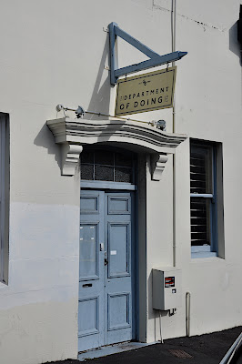
Since August 4th was my last full day in Sydney, I set out to see how much of what I'd missed so far that I could squeeze into the one day... and this means LOTS of photos so am splitting the day into two posts.

Breakfast, check... camera gear, including tripod and three lenses, check... off to Sydney Tower to go up and see the 360° views of Sydney... but first one must experience the "OzTrek" virtual reality visit to some of Australia's most well-known locales. After a ho-hum twirl around in small theaters (the visitor group is split into fourths for the first part of OzTrek) listening to an Aussie guide (real person) superimposed on several classic, diorama-type views of Australia (outback, barrier reef, etc.), the REAL fun of OzTrek begins. Strap yourselves in for the ride of your life... Your OzTrek journey excites the senses with its 180-degree cinema screens, special effects with sensational surround sound and heart-stopping real-motion seating! Believe me, I was hanging on for dear life but it was wonderful!

I'm including a few views taken from the observation deck and some taken after my descent to the street level world of Sydney... my next post (later today or tomorrow) will have more of my last day's experience... the highlight of which was walking along the Cahill Expressway pedestrian walk to get to the Sydney Harbour Bridge pedestrian pathway.

photo of St. Mary's Cathedral
St. Mary's Cathedral as seen from the Sydney Tower Observation Deck...
view of Sydney, NSW, AU from Sydney Tower
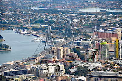
The Anzac Bridge, Sydney's other well-known bridge, was given its name on Remembrance Day 1998 in honor of the Australian and New Zealand Army Corps soldiers who fought in WWI. It is visible in the middle distance of this photo taken from Sydney Tower's observation deck and is Australia's longest cable-stayed bridge according to Wikipedia. Ruth and Guy (my hosts in Sydney) live not far from the Anzac Bridge in the Lilyfield area of Sydney. The next photo is a closer view taken from the same vantage point.
Anzac Bridge, Sydney, NSW, AU
Although this bridge is quite close to where Ruth, Guy and Andrew live, I never made it down there on foot. There is a wonderful fish market on the water near the bridge and we stopped there on my first day in Australia so Ruth could pick up some fish for our dinner that evening.
Sydney Harbour Bridge and skyline from Sydney Tower
A larger view of this photo shows some familiar company names (at least, familiar to those in the computer field) with Australian offices in Sydney... Hitachi, Sharp, Samsung, Cisco... to name a few.
Goddess Diana in Hyde Park fountain, Sydney, NSW, AU
With my feet back on the ground, I headed for St. Mary's Cathedral through Hyde Park and captured this view of the goddess Diana in Hyde Park Fountain, Sydney, NSW, AU...
Sydney Tower
As I was lining up my camera to capture a view of Sydney Tower against the sky, a nice gentleman stopped and informed me that there was a much better vantage point on the steps of St. Mary's Cathedral... which is exactly where this photo was taken. He also advised me how to go about taking the walkways to the pedestrian pathway on the Harbour Bridge so I decided to add that to my afternoon plan... more on this adventure in my next post. (later today or tomorrow)

Tuesday, August 25, 2009

Return to Sydney, NSW, AU... vacation winding down...

With an approximately 3 hour (maybe more) drive a head of me and a 1 PM flight from Auckland International to make, I awoke early, grabbed a quick breakfast, loaded the car and was on the road by 7:20 am... leaving Rotorua behind but not my many memories of the sights I'd seen and the adventures I'd had. My drive to the airport was uneventful but quite nerve-wracking for the last half hour before arriving at the airport... roads around the airport are under construction and the signs weren't exactly plentiful... at one point I was about to turn around and head back because I was certain I must have taken a wrong turn OR missed a turn I should have taken. Luckily, I stayed the course and saw a sign a few seconds further that assured me I was on the right route!

With the time zones in my favor, I landed in Sydney at 2:30 PM local time and was at my hotel (the Russell, in the Rocks district of Sydney) by shortly after 4 PM whereupon I dumped my luggage and headed out to explore the neighborhood and capture a few late afternoon, early evening shots of the Sydney Opera House and the Sydney Harbour Bridge.

Sydney Opera House
Late aftenoon sunlight on the Sydney Opera House...
view of Sydney Harbour, skyline and boats
Sydney Harbour view with skyline, ferry boat and sailboat..
ALTtag
Late afternoon sunlight streams through the windows of the Pylon Lookout of the Sydney Harbour Bridge...

Friday, August 21, 2009

Hiking in Waimangu Volcanic Valley, Waimangu, NZ

Woke up feeling somewhat recovered from my cold so went ahead with my plan to hike along the trails in the Waimangu Volcanic Valley about 25 km from Rotorua. Since this was to be my last full day in New Zealand, it was my last chance to explore this unique thermal area created by the June 10, 1886 eruption of Tarawera. That event opened a line of craters all along the rift zone of the multiple eruptions, forming several craters and thermal features and completely destroying the Pink and White Terraces as well as all plant and animal life in the area affected by the eruptions. The Waimangu Volcanic Valley is the only hydrothermal system in the world that was completely formed during recorded history, as well as the only New Zealand example of a biosystem naturally reestablishing itself after total destruction.

After a leisurely breakfast and organizing myself and my camera gear for a day of hiking and exploring, I was on the road by about 10:30 AM, arriving at the visitor center around 11 AM after a couple of stops to snap some photos... Of course! I'd decided to hike and then take the boat ride around Lake Rotomahana (formed (from a smaller lake in the same spot) in its current configuration by the 1886 eruptions) to see more of the thermal features available only by boat.

The "wanderer's guide" to the hikes suggests that 2 hours is the time required for the easy hikes and says that allows for stopping to take pictures. HA! Suffice it to say that I managed to make it to the boat dock on Lake Rotomahana in time for a few photos of the lake area before the 2:50 PM boat left the dock. The boat captain asked the bus driver, as I got on the boat, "Is this the 1:10 PM lady?" (1:10 PM was the time the Visitor Centre estimated that I would make the boat ride when I purchased my admission to the Park at ~ 11 AM) One thing to note, however, is that I took the side trip to the Mt. Haszard Trail which is billed as requiring good fitness, having steep hills and rough underfoot and requiring up to one hour to complete just that portion of the trail. And I became TOTALLY side-tracked at one point by attempts to capture a bumble-bee going after pollen in what I think was a form of heather flowers.

All in all, I took FAR too many photos to post them all anywhere for fear of boring everyone to tears... but here are a few for you to peruse.

view of rift valley from outside visitor center at Waimangu Volcanic Valley
View of the rift valley taken from the Panorama scenic lookout outside the Visitor Centre for Waimangu Volcanic Valley.
wood carving at start of trail in Waimangu Volcanic Valley
This is Ruaumoko, Vessel of Remembrance, at the start of the hike from the Visitor Centre to the boat landing at Rotomahana Lake. From the wanderer's guide: The surface design of the statue includes spirals (Koru Rangi) put on all points of movement to bring the ancestor to life. The bulb in the middle of the spiral pattern is "Koru" (symbol of rebirth). Rangi is the divide/contrast between the Haehae (the cut line, to slice) and Pakati (the knotch, to cut deeply).
inferno crater lake, waimangu volcanic valley, nz
Inferno Crater Lake, Waimangu Volcanic Valley, NZ... From the wanderers guide I learned that this lake is somehow linked to Frying Pan Lake and the level of Inferno Crater Lake ebbs and flows and coincides with greater and lesser discharges from Frying Pan Lake, respectively.
tourist at scenic viewpoint on Mt. Haszard hiking trail in Waimangu Volcanic Valley
Tourist (yours truly) at scenic viewpoint on Mt. Haszard hiking trail in Waimangu Volcanic Valley, NZ. This is the highest point on the Mt. Haszard trail. The next photo is from the name spot without the tourist and with a somewhat wider view as well as a caption explaining what you are seeing.
ALTtag
View of Lake Rotomahana (middle distance) and the Tarawera Volcano from the Rift Valley Panorama. The large hole (just below the horizon line about 1/3 in from the left edge of the photo) is where the side of the mountain blew out in the 1886 eruption of Tarawera Volcano. (also visible if you look closely on the left part of the photo above the trees in the foreground is steam rising from the walls of Black Crater, another geothermal feature created by the 1886 eruptions)

Thursday, August 20, 2009

Visit to Whakarewarewa Thermal Village, Rotorua, NZ

Seems that my cold got the better of me and I slept until almost 9:30 AM on my first full day in Rotorua but luckily awoke in time to have cereal, juice, coffee and a sweet roll at the breakfast provided by the Ventura Inn & Suites of Rotorua, my home away from home in Rotorua. The weather was not terribly promising and I certainly wasn't feeling well enough to tackle an all day adventure. So I organized myself for a visit to Whakarewarewa Thermal Village, a "living thermal village" a short distance away from my motel.

Hoping for the best in terms of the weather, I managed to find parking a couple of blocks away from the visitor center for Whakarewarewa (often shortened to Whaka by the locals), paid my entry fee AND discovered the reason for the lack of parking is that there had been a funeral that morning at the Wahiao Whare Tipuna (Whare Tipuna = Ancestors House). This is not only where they hold their funerals but is the Meeting House for all the major events of the Village. From the Visitor Guide I learned that The best of all Maori carving is saved for the Whare Tipuna. The carver takes pride in displaying all his skills and knowledge as he recreates Whakapapa (genealogy) for all to see. Without a written language he recreates a story through his carvings. The house is named "Wahiao" after our great ancestor.

The tour began with our guide standing in front of the sign post naming the village by both the original full name of Te Whakarewarewatanga O Te Ope Taua Wahiao and the shorter Whakarewarewa (still somewhat unpronounceable for native English speakers). The name of the village translates to mean "The gathering place of the army of Wahiao" and adopted this name in honor of Chief Wahiao who, three hundred years ago, gathered an army to successfully avenge the killing of his father.
guide at Whakarewarewa Thermal Village, Rotorua, NZ
As our tour continued, we learned many things about life in this Maori Village, including that corn is boiled daily (for the Hangi Feast served as lunch at the café in the village) in Parekohuru (Vigorous Ripples) pool.
cooking corn in thermal pool
And we learned that the modern homes in "Whaka" village use both thermal and solar energy to meet their energy needs. (an original Maori home built using thermal energy may be seen on my photoblog)
modern homes in Whakarewarewa Thermal Village
Once the tour ended, we were encouraged to go visit the meeting house which had been off limits to tours due to the funeral earlier in the day. But respectful visitors were allowed to stop by on their own which led me to take the photo below from the porch of the café across the street and slightly uphill.
Maori meeting house
I'd planned to take one of the longer hikes available to visitors as self-guided tours, but the pouring rain that started shortly after the formal tour ended discouraged me from doing that. The following photograph was taken from Pohutu Geyser Lookout and the strange structure visible above the trees across the way is part of the Te Puia Village museum complex.
view of geysers from Geyser Lookout
A return trip to Rotorua would definitely have me visiting Te Puia Village since it is the village where Maori craftsmen and women demonstrate their time-honored crafting traditions and of course, sell their wares to tourists wishing to purchase souvenirs.

Sunday, August 16, 2009

On the road again... from Auckland to Rotorua, NZ

My time in Auckland at end, I collected my rental car from Thrifty (three days for the price of two and they picked me up at my hotel) and was on the road to Rotorua by 10:30 am. I'd packed a lunch since I had no clue what my options would be while traveling through unknown territory. The left-side road driving didn't confound me (had had two weeks "down under" to get used to it) and the trip was relatively uneventful, passing through beautiful farmland and quiet towns en route.

Although I stopped a couple of times to take photos, I was at Rainbow Springs (a few kilometers from Rotorua) for the 2 PM Kiwi tour where I learned how they are working on bringing back the Kiwi population. If left in the wild, the survival rate for Kiwi chicks is about 5% but under management as is done at Rainbow Springs, the survival rate is on the order of 60% and chicks are returned to the wild at about six months of age. Photography isn't allowed on the Kiwi tour (it disturbs the hatchlings and the adult birds as well) but I've included a couple of photos taken en route to Rotorua below.

New Zealand countryside, farmland with country lane
This scene reminded me of a Cat Stevens lyric... "Miles from nowhere.. on the road to find out.." At least I think that's how it goes... When I stopped on the side of the road to take this photo, I was surprised to find a feathered friend (below) visiting on what appeared to be a completely deserted stretch of road...
beautiful chicken
I have NO IDEA where this bird belonged... there was no farmhouse in sight, nor a barnyard anywhere near where I'd parked. He (?) just suddenly appeared next to my car and startled me a bit when I turned around to get back in the car.

No visit to Rotorua is complete without attending a Maori cultural experience... an evening of story telling, dance and food (Hangi feast) designed to teach visitors some of the history of the Maori and give them a taste of the native culture. My first evening in Rotorua included the show at the Mitai Maori Village and was quite enjoyable (in spite of the miserable cold that I had at the time). The food was fantastic! Took too many photos to post them all but here are a couple for you...
Maori warriors doing a war dance
The chief (in the background) is urging the warriors into a frenzy in preparation for going into battle.
Maori warrior
Close-up of one of the younger warriors performing at the Mitai Maori Village.

Monday, August 10, 2009

Second Day in Auckland, New Zealand

Since I had a bit of a cold AND it was a rainy morning, I chose to sleep late and take the Waitakere Rainforest and black sand beaches tour with Bush and Beach Tours in the afternoon. Since it appeared that we would need to provide our own lunch, I asked at the desk at my B&B to recommend a good place to get a sandwich to take along for the afternoon... Subway was the desk clerk's recommendation because, he said, "it is healthy and other places do not give you healthy food." So I've come half-way around the globe to be told to eat at Subway! (took his advice and on the way to Subway, found the delightful O'Connell Street Bistro and made a reservation for 7:45 PM dinner meal that turned out to be one of the best dining experiences I've ever had... highly recommend this restaurant if you ever find yourself in Auckland, NZ... it's tiny and I was very lucky to get a table on short notice)

The tour was really wonderful in spite of the rain that seemed to follow (or precede) us from point to point along the way. There was myself, Mohammed (from Abu Dhabi) and Eileen (from Germany) on the tour led by Stan of Bush and Beach Tours. Our first stop was the Arataki Visitor Centre in the Waitakere Rainforest where we had the opportunity to see wonderful vistas looking back toward Auckland, the Wiatemata Harbour, Rangitoto Island and the Pacific Ocean as well as looking the other way toward the Manukau Harbour (Auckland's second harbor) and the Tasman Sea. We also had time to wander through the visitor center and the outdoor boardwalks to learn a bit about the local flora and fauna. I'm personally glad I never saw a weta any closer than I did through the glass at the visitor center! I've had a hard time choosing photos from this tour but what follows are a few representing the wonderful sights we saw and/or the things we did on this four hour tour (snack included!).

rainbow over the rainforest
Rainbow over the rainforest as seen from the Arataki Visitor Centre in the Waitakere Rainforest, North Island, New Zealand.
map of Auckland and Waitakere Rainforest area
Map showing red dot representing Arataki Visitor Centre and where we were when the photo above the map was taken. Our tour continued along a southwesterly course from that spot.
Stan preparing afternoon tea
We luckily had a break in the rain for our afternoon snack break which included cookies and a choice of tea, coffee (instant, I had tea!), water and/or juice... all the comforts of home except for brewed coffee.
Kauri tree stump and three tourists
New Zealand Kauri trees were harvested all over New Zealand for the wood which is durable and beautiful. There are now protected forests where the trees are coming back. This one would have been over one thousand years old at the time it was harvested, perhaps several thousand years old. We saw 'young' trees that were 'only' four to six hundred years old that were about one third the diameter of this tree stump. I asked Mohammed, Eileen and Stan to stand in this photo to give a sense of scale to the tree trunk... Mohammed moved just as I snapped the photo.
sunset sky
This photo was taken from the van while stopped at a traffic light en route back to Auckland at the end of the day's tour.

Saturday, August 1, 2009

First full day in Auckland... Touring by Bus and Ferry

Managed a reasonably early start following breakfast at my B&B (simple options of cereals, white and wheat bread for toast, OJ and apple juice, instant coffee (UGH) or tea)... purchased a hop-on/hop-off, all day bus ticket for a bus that takes an hour drive around some of the sites with commentary as to what one might do while waiting for the bus to return in one hour if one hops off at any of the stops. (Note that summer time buses run every half hour which makes for shorter waiting times in between buses.)

As I am somewhat weary of playing tourist at this point (and feel a cold coming on), I opted to stay on for the circuit and then hopped a ferry to Devonport for another bus tour around that lovely little seaside town. After the ferry dropped me off, I had time to shop a bit as well as grab a bite to eat at a local café before hopping on another bus for a ride around the Devonport area with stops at a couple of the higher points of land for photo opportunities.

On my return to Sydney, I walked up Queen Street and turned onto Victoria Street to make my way to the Sky Tower... what an incredible structure from which to view the entire Auckland area as far as the eye can see! Had a lovely chat with a couple from the South Island while having a glass of wine in the Sky Café at the main observation level. We agreed that bungee jumping (which could be done from a level above where we were sitting) was not for us... but managed to catch some jumpers on camera while chatting.

What follows are some photos of today's adventures...
Auckland Skyline with view of Sky Tower
This was taken from somewhere on the bus ride around Auckland.

Rangitoto Island as seen from Devonport
This is as close as I got to Rangitoto Island, a 600 year old volcanic island guarding Waitemata Harbor. Seems that they are having an aggressive poisoning campaign at the moment in an attempt to rid the island of rats once and for all. Although it was perfectly safe to visit, the notion of them trying to get rid of rats put me off the idea of going there.

Looking toward Auckland from Devonport
The views from Devonport looking back toward Auckland City and its suburbs are quite lovely from various vantage points on our bus ride. (also note ferries coming and going)

Door sign above the doorway to the Department of Doing
No idea what this place is about... the Department of Doing in Devonport seemed to be closed and thus was not doing anything as near as I could tell!

Looking UP at the Sky Tower
It is quite dizzying to look up at the Sky Tower from down below.

Bungee Jumper paused at Observation Deck, Sky Tower, Auckland, NZ
I couldn't figure out what was going on at the observation deck... LOTS of people waiting in front of two of the many observation areas... then WHOOSH... here came a bungee jumper... pausing for photos in front of the viewing area. Seems this gal made at least three jumps while friends watched and waited for her to finish having adrenaline highs.

Leaving Sydney, AU... arriving Auckland, NZ... the Journey Continues...

An early morning departure from Ruth and Guy's courtesy of the Silver Service Taxi finds me at the airport in PLENTY of time to make my 9:30 AM flight. Am not sure why Air New Zealand wants passengers through check-in 90 minutes before flights depart and at the gate one hour before departure because nothing happens at the gate until about 25 minutes before boarding at which time they efficiently board everyone at once... first and business class through one entry and the cattle (economy) class through a different entry.

I couldn't resist taking a few photos on departure from Sydney as well as some cloud shots en route... one of each follows... I quite like the one that shows the window frame in it as well as my partial reflection as I snapped the photo.
last view of Sydney, AU en route to Auckland, NZ

view of clouds from airplane window


By the time I arrived at my hotel, settled in and was ready to go out and have a short look around town, it was already dark. So no photos of Auckland until tomorrow. Had a lovely pub supper (tomato soup, Galway mussels (done with wine, garlic and herb broth) and fresh vegetables) along with some Murphy's Irish Stout to wash it down at a pub on the waterfront area. Danny Doolan's (if memory serves) was established in 1906, seems to be a neighborhood gathering spot and definitely serves good food if my dinner is any indication of their other offerings!